Tour Your Way Through Munising

Munising is located in the Upper Peninsula and is one of the most scenic areas in Michigan.
Our area offers unique attractions year-round. Spring and summer activities include golf, boating and camping. Winter hikes and snowshoeing are a must-do. Attractions abound with Pictured Rocks, Horseshoe Falls, Hiawatha National Forest, and many more. Voted one of the best small towns for fall travel in 2017.
Tour your way through beautiful waterfalls, to Pictured Rocks, and everything in between with the Munising of Pure Michigan Map-N-Tour App.
Waterfall Tour:
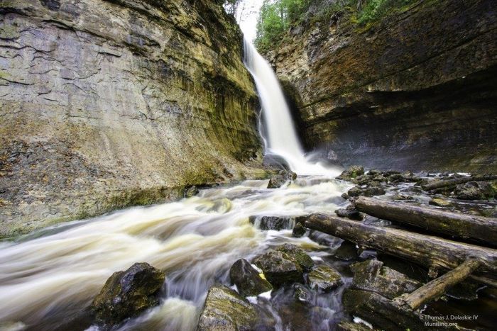
Munising invites you to come and discover our wonderful waterfalls that provide opportunities for tranquility, relaxation, education and fun. Many of the Alger County waterfalls are accessible year-round and are especially beautiful during the winter months. Come and explore the beauty of the Munising area in the winter, and snowmobile to the numerous waterfalls to see just how incredible they are.

Lace-up your hiking shoes, grab a snack, water, map and compass, and head down the trail to adventure.
The seventeen Alger County waterfalls include: Alger Falls, Au Train Falls, Bridal Falls, Chapel Falls, Horseshoe Falls, Memorial Falls, Miner Falls, Laughing Whitefish Falls, Munising Falls, Rock River Falls, Miners Beach Falls, Scott Falls, Spray Falls, Sable Falls, Wagner Falls, Whitefish Falls, and Tannery Falls.

Shoreline Tour:
Unique to our area and by far our largest summer attraction is the Pictured Rocks National Lakeshore. The name “Pictured Rocks” comes from the streaks of mineral stain that can be seen on the face of the weather-sculpted cliffs. An array of colors occurs when groundwater seeps through the cracks and trickles down the rock face. Iron (red and orange), copper (blue and green), manganese (brown and black), limonite (white) are among the most common color-producing minerals.

Pictured Rocks National Lakeshore is managed by the National Park Service as one of only four National Lakeshores. The Pictured Rocks tower 50 to 200 feet directly from Lake Superior and stretch for about fifteen miles along its 42-mile length. In addition to the Pictured Rocks, the lakeshore also offers 12 miles of beautiful beaches, nearly five miles of enormous sand dunes, several waterfalls, and lighthouses. Within the park, over 100 miles of trail lead to remote lakes, streams, and forests to explore.
The park is open year-round and is truly a four-season recreation destination with ice climbing, cross-country skiing and snowshoeing, snowmobiling, ice fishing, hiking, canoeing, kayaking, sightseeing, birding, backcountry and vehicle-based camping, and more.

Words cannot fully describe the beauty of Pictured Rocks National Lakeshore. To help you to appreciate the lakeshore to its fullest, while in town stop by one of the Visitor Information Centers in Munising or Grand Marias, visit NPS.gov/piro or call the Pictured Rocks National Lakeshore Visitors Center at 906-387-3700.
Lighthouse Tours:
The Munising and Alger County area offers a great selection of interesting, beautiful and historic lighthouses for viewing and photographing.

Since the Grand Island North Lighthouse and East Channel Lighthouse are both located on Grand Island, the best way to view them is by water. The North Lighthouse is located on the north end of the island and is on private property. The East Channel, located on the southeast shore of the island, is known to be one of Michigan’s most recognizable landmarks. It’s primarily constructed of brick and wood and resembles an old schoolhouse or church. Take one of several cruises offered or rent a pontoon in the area to see this beauty up-close. This is a privately-owned structure and the dwelling, tower and grounds are closed to the public.
Established in 1874, the Au Sable Point Light Station-12 miles west of Grand Marais-is 86 feet high and delivers a strong, 18-mile beacon out over Lake Superior. On the beach below the trail, exposed shipwreck remains dot the shoreline. Lighthouse tours are available mid-June through the end of September, Wednesday-Sunday only.

The Munising Range Lights – Front and Rear, established in 1907, are in Munising. The sites are open to the public, but the towers are closed. The rear light was placed on the hillside at the south end of Hemlock Street in Munising. This light shines a continuous red light. The lighthouse is painted white and stands 33 feet in height. The Front Range light, also painted white, was constructed of steel and stands 58 feet in height.
West from Munising is the town of Christmas. Look for the “Welcome to Christmas” sign to find the Grand Island Range Lights. Established in 1867, the Grand Island Harbor Range Lights, also known as the “Bay Furnace Lights,” are made up of two lights. The front light is located along the water’s edge and there is a hiking trail that leads to it for easy viewing. The rear light is across M-28 from the trail.
Explore these tours and more with the Munising of Pure Michigan Map-N-Tour app, available for both desktop and mobile.
About the Author: The Munising Visitors Bureau operates under Michigan Public Act 59 as a nonprofit organization that’s funded through the collection of a 5% occupancy/assessment tax to pay for promotions, marketing programs, events and other projects around the Munising area.